
Derry Township Neighbors: Block Records
A block lookup should identify the type of fact needed before a parcel is opened. The county map and tax system can show a parcel and listed owner. The Recorder can show a property transfer. Township planning material can explain a project or corridor. None of those sources creates a roster of everyone who lives nearby.
| Block source | What it can show | Access and boundary |
|---|---|---|
| Dauphin County Parcel Viewer and Tax Inquiry | Parcels around a selected property and the listed ownership record for each. | Public county tools; map is reference material and owner data is not household data. |
| Recorder of Deeds | Ownership transitions, parties, dates, document type, and legal-description trail for an identified parcel. | AcclaimWeb or counter; documents show a property transaction, not resident count. |
| Township planning and map material | Roads, parks, flood or planning context, permits, and project evidence. | Community Development and narrow RTKL or counter request; no verified public address database. |
| Voter street-list channels | Statutorily controlled registration data. | Not a browseable block directory; use is subject to 25 Pa.C.S. §§ 1207 and 1404. |
| Local historical collections | Maps, newspapers, family files, deeds, obituaries, and contextual neighborhood history. | Appointment archives and State Archives records; date and source scope must be checked. |
Derry Township neighbors are better understood as nearby parcels, historical properties, and community geography than as a list of named households. That distinction protects accuracy as well as privacy.
Map Derry Township Neighbors
The local parcel method is manual and specific: identify one property, inspect nearby parcel boundaries, then confirm each selected parcel through its own county record. The Parcel Viewer does not have a documented automatic adjacent-parcel or neighbor-radius button. Do not infer ownership from a map label or assume that every close parcel shares a street address.
- Find the target in Dauphin County Property Tax Inquiry by verified address, parcel, or other property field.
- Copy the parcel or UPI, municipality, current owner spelling, sale or deed reference, and legal-description clues.
- Open the parcel in the Dauphin County Parcel Viewer and visually identify boundary-touching or nearby parcels.
- Look up each selected parcel independently in the tax system, then use the Recorder only for a property document trail that needs confirmation.
- For a longer chain along a named road, move to the Derry Township street directory rather than expanding a block search into a whole-street claim.
This approach keeps the address, parcel, owner, and document roles distinct while allowing a useful block-level view.
Derry Township Neighbor Parcel Controls
The Parcel Viewer exposes Map Search, Search for Parcel, Parcel Search, Property Info, Tax Assessment, Recorder of Deeds, and Open Data. Parcel Search is an exact Parcel ID search with the displayed `##-###-###` format hint. Map Search accepts a parcel-ID beginning pattern with a `##-###` hint. Point, Rectangle, and Polygon controls support manual geographic selection, and the map can report distance and area in U.S. feet and square feet.
Its parcel popups expose Parcel ID, Municipality, assessed land and building values, street-number parts, acres, and a Tax Record link. The County says the map represents deed and survey information, is updated weekly, and carries no warranty for positional or thematic accuracy. Use it to orient research, then rely on the custodian record for an official document question.
Historic imagery choices exposed in the current Viewer configuration include 2025 EagleView, 2024, 2022, 2020-21, 2018, 2016, 2014, 2011, 2008, and 2003. An image can help place a building or land change in time, but it cannot identify residents or prove a property relationship. Pair it with a dated assessment, Recorder document, permit file, or archive source when a block-history question depends on timing.
Derry Township Neighbors Are Not Owners
This County-owned parcel record illustrates the kind of property detail available from a tax record. A record may display the listed owner, tax-mailing address, physical property address, land and building data, and deed or sale references. It does not prove who resides there, whether a listed owner is present, or whether other people live at the property.
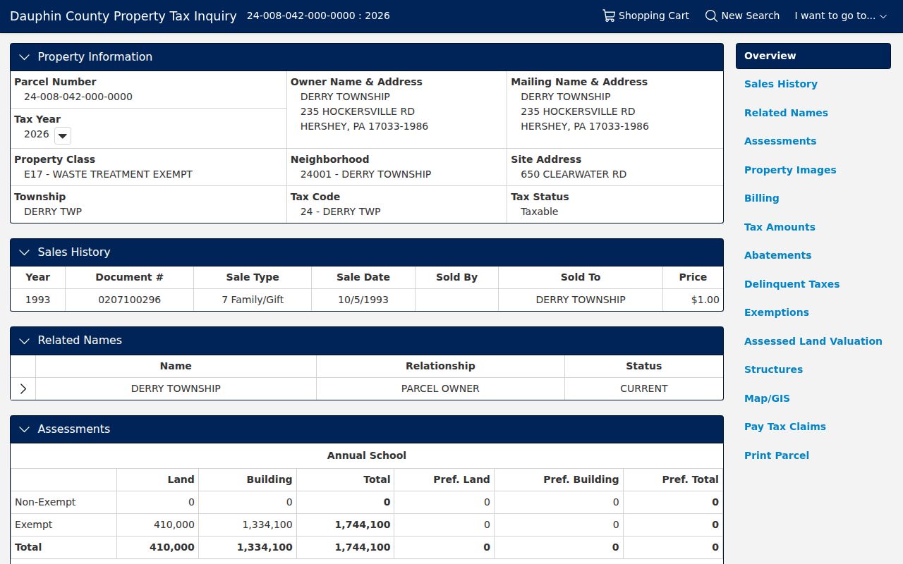
Use the owner field as a property relationship. A mailing address can be off-site, a post-office box, or an alternate correspondence address. A parcel's situs is the land location, while its legal description is the deed's land identity. Each answers a different question.
| Parcel owner record | Supports a current listed ownership question, subject to the system's data date. |
|---|---|
| Household occupancy | Not established by the owner or tax-mailing field. |
| Boundary proximity | Can be viewed on the map, but does not by itself create an association between households. |
| Recorded transfer | Can be confirmed through the Recorder for the identified parcel. |
Derry Township Neighborhood Communities
Pennsylvania's legislative community-interest inventory names several Derry Township community or HOA geographies. The list provides a geographic lead only. It does not prove that an association currently operates, that a particular home belongs to it, or that it has a public member directory. No association contact details are supplied here because official status and contact information were not verified one community at a time.
| Named community geography | Named community geography | Named community geography |
|---|---|---|
| Cambridge Commons | Crest of Hershey | Deer Run of Hershey |
| Hershey West End | High Pointe at Hershey | Hygate |
| Oakmont | Orchard Run | Regency Hills Condominium |
| Ridgeview | Rockledge Palmyra-Wexford | Shady Hill Estates |
| South Point of Hershey | Stone Creek | The Park at East Caracas |
| Village of Innsbruck | Community geography only | Verify locally before relying on it |
Use a community name to refine a parcel or planning search. Treat it as a neighborhood clue, not a way to identify or contact individual neighbors.
Derry Township Neighborhood Development Records
Derry Township Community Development holds building, zoning, planning, code, maintenance, and stormwater responsibilities. For an area change, a permit or planning question may provide public project context. The research did not find a public address-search database, so the appropriate fallback is a narrow request or counter inquiry that names the property, time range, and record type.
Community Development materials can establish a project, approval, setback, plot-plan, or planning context. They do not identify every occupant of a nearby address. The 2017 Official Map is similarly useful for roads, trails, parks, flood planning, and the Route 322, Walton Avenue, and Hershey Downtown corridors without being a people record.
Derry Township Neighbors and Voter Lists
Pennsylvania's voter-status service is for an individual to check status or polling-place information. It is not a public browse-by-street tool. Public street lists and other voter information are governed by 25 Pa.C.S. §§ 1207 and 1404, which require identification and a written permitted-use statement for list acquisition. Electronic signatures and SURE registration numbers are excluded.
Those rules mean a voter list cannot become a public neighborhood roster. The correct channel is the election authority and its statutory request process. The County elections office can also explain current access procedures without changing the underlying privacy and use boundaries.
Note: A statutory street-list request is different from a personal voter-status check and does not establish household occupancy.
Derry Township Neighbor Search Comparison
Official parcel research and commercial neighbor-search products are not equivalent. A commercial category may combine mixed sources that are stale or cannot distinguish an owner, renter, prior occupant, or protected person. The official path has narrower coverage, but it identifies the custodian, record date, and property role so the result can be checked.
| Official parcel and Recorder path | Commercial neighbor-search category |
|---|---|
| Shows a defined public record, source office, parcel link, and dated document route. | May combine sources with uncertain date, status, and relationship to the address. |
| Separates property ownership from occupant information. | May blur owners, prior residents, and household members. |
| Allows direct confirmation with Tax Assessment, GIS, Recorder, or the Township. | Cannot make protected, sealed, or custodian-limited data public. |
Lawful use. Use Derry Township neighbor information for lawful personal, historical, civic, property, or safety purposes. Do not use it to monitor, stalk, harass, intimidate, or harm any person.
For a suspected deed issue, confirm the actual document in AcclaimWeb or at the Recorder before acting on a notice or online claim. Dauphin County's Record Notification Service can alert a subscriber when a later document is recorded against a name, property, or parcel. It is an alert service, not proof of fraud, a title examination, or a substitute for the property document itself. The direct-record check keeps a block question grounded in the county's dated record rather than an unverified summary.
Derry Township Neighbor Lookup Limits
Renters and household members are not listed in county owner fields. Utility customers, delivery lists, and driver addresses are not a public neighbor-search channel. Pennsylvania's Address Confidentiality Program can supply eligible victims of domestic violence, sexual assault, stalking, human trafficking, or child abduction with a substitute mailing address in many records. It is designed to protect a location, not to be bypassed.
When a property claim matters, check the Recorder's direct document and consider the County Recorder's Record Notification Service for alerts tied to a name, property, or parcel. The service can flag a subsequent recorded document, but it is not a title search, fraud finding, or guarantee. For Township-held records, Pennsylvania's Right-to-Know Law, Act 3 of 2008, 65 P.S. §§ 67.101-67.3104, offers a request route subject to exemptions and redactions.
Block history has a separate access path. The Hershey History Center's local deeds, maps, newspapers, family files, cemetery material, obituaries, oral histories, and photo archive can help explain how an area changed over time. Hershey Community Archives can add local organization, business, and construction context. Ask those repositories for a place and period, then compare any historical finding with a county parcel or Recorder document before connecting it to a property.
For an immediate safety concern, use emergency services rather than a property or neighbor search. Record systems are delayed, partial, and designed for different purposes.